

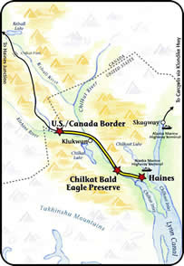
This highway connects the Inside Passage community of Haines with Haines Junction in the Yukon Territory. First used by the Chilkat Indians, the highway became a packhorse trail to the Klondike goldfields in the late 1880's. In 1943, the U.S. Army used the highway as a military access road during World War II.
This byway is encompassed by the lush coastal rain forest as it makes its way up the St. Elias Mountains and into Canada where the forest gives way to alpine tundra and the Haines Highway connects with the Alaska Highway at Haines Junction.
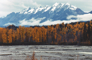 Fall color in Haines. © Haines Borough
- Enjoy a walking tour of Fort William H. Seward
- Established in 1982, the Alaska Chilkat Bald Eagle Preserve is seasonal home to 3,000 bald eagles. They are attracted by fall and winter runs of salmon in the Chilkat River. It is common to view hundreds of these regal birds roosting in the cottonwoods along the Haines Highway between October and January.
- Watch for fish wheels being used on the Chilkat River in June.
- To the west is Canada's Tatshenshini-Alsek Wilderness Park, home to grizzlies, Dall sheep, rare glacier bears and birds.

January
-
Alcan 200 International Snowmachine Race
Haines, 907-766-2503
May
- Alaska Craftbeer & Homebrew Festival
Haines, 907-766-2476 - Haines King Salmon Derby Memorial Day weekend
Haines, 907-766-3885
June
-
Kluane to Chilkat Bike Relay
Haines, 907-766-2202 - Summer Solstice Celebration
Haines, 907-766-2476
July
- Fourth of July celebrations Regionwide
Haines, 907-766-2234 - Southeast Alaska State Fair & Bald Eagle Music Festival
Haines, 907-766-2234
November
-
Alaska Bald Eagle Festival
Haines, 907-766-3094
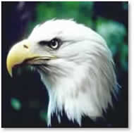
Bald eagles gather in trees at the council grounds in the Bald Eagle Preserve on the Haines Highway.

- ADF&G Wildlife Viewing Information
- Haines Convention & Visitor's Bureau
800-458-3579
PO Box 530, Haines, AK 99827
 hcvb@haines.ak.us
 - Sheldon Museum & Cultural Center
907-766-2366
PO Box 269, Haines, AK 99827
curator@sheldonmuseum.org - American Bald Eagle Foundation
907-766-3094
PO Box 49, Haines, AK 99827
info@baldeagles.org
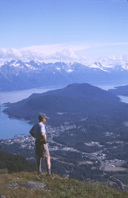
View of Haines and Lynn Canal from Mt. Ripinsky in the summer.
Questions about the Scenic Byways web site? ![]() dot.scenic.byways@alaska.gov
dot.scenic.byways@alaska.gov
Scenic Byways List
- Alaska Marine Highway - Inside Passage
- Alaska Marine Highway - Gulf Coast Route
- Alaska Railroad
- Copper River Highway
- Dalton Highway
- Glenn Highway
- Haines Highway
- Kachemak Bay Route
- Parks Highway
- Prince of Wales Island Road System
- Richardson Highway - north segment
- Richardson Highway - south segment
- Seward Highway
- Steese Highway
- Sterling Highway - north segment
- Sterling Highway - south segment
- Taylor & Top of the World Highways
- Walden Point Road