
Roads to Resources
HIGHLIGHTS
| Statewide | Northern Region | Central Region | Southcoast Region |
Statewide:
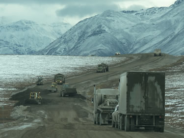
Road widening using B-70s to dump material, Dalton Highway 274- 289, August 2011. Photo by Raquel Ream, Alaska DOT&PF
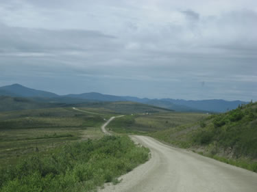 Taylor Highway to Eagle. Photo by Joanna Reed, Alaska DOT&PF
- Industrial Highway User Fee Study – The department is reviewing options and practices for documenting road and bridge wear and damage associated with over-weight truck combinations that are expected to be seeking permission to carry large loads of mineral concentrate and other resource products to market. The study will also examine options for setting and collecting fees for overweight trucks.
- Alaska State Rail Plan – This plan will examine rail extension options that could benefit, or even make possible, resource development opportunities. There is a special webpage for the rail plan on the DOT&PF homepage. Visit the railplan website.
- Trans-Border Transportation Task Force – The Task Force brings together Alaska transportation officials and Yukon provincial transportation staff twice annually to discuss topics of mutual interest. Topics include mine related traffic on highways that cross the border; the challenges associated with building on permafrost; funding issues associated with MAP-21; and administrative concerns such as training and procurement.
Northern Region:
- Foothills West Transportation Access - This project will provide access to known gas and oil reserves on the north side of the Brooks Range, about 100 miles west of the Dalton Highway. A Notice of Intent to initiate an EIS was issued on May 20, 2011. Since then, numerous baseline investigations to evaluate three alternatives were conducted. Linc Energy, Inc., an oil and gas development company that is making a substantial investment into oil exploration at Umiat, has begun their own baseline and preliminary environmental work that overlaps project fieldwork that DOT&PF has been conducting over the past few years. While not definitive, it appears Linc Energy is preparing plans to develop Umiat oil, along with a pipeline and a potential road that may access the Dalton Highway similar to the alternatives being studied for the Foothills EIS. DOT&PF is currently re-evaluating plans for future EIS work to ensure that the Linc Energy and DOT&PF EIS work does not conflict, and efforts are not duplicated.
- Ambler Mining District Access – This project is to provide an all-season transportation access road to promote exploration, development, and production of known mineral resources in the Ambler mineral belt. Reconnaissance level engineering evaluations are completed and baseline field studies are largely complete. Many meetings have been held in the communities along the likely routes to discuss the effect of improved transportation access and measures to mitigate impacts on cultural and subsistence values. This will be an example of private funding where AIDEA will raise the money from the bond market to build the road. For that reason, project management was shifted to AIDEA during the first half of 2013.
- Road to Tanana – This project is to provide improved road access to known mineral developments in the Manley region mineral belt to support mining opportunity expansion and resource exploration, plus provide an all-season road to the Yukon River near the community of Tanana. The road will improve access to Tanana by connecting to the Elliot Highway near Fairbanks. The project will support regional and community sustainability by reducing the cost of living and providing greater opportunities for employment and commerce to the Tanana to Manley region. In 2013, the project was refined into a Corps of Engineers permit application and a Corps permit has now been issued. Construction began in late 2013.
- Dalton Highway Traffic Forecast – This is an effort to look into the future to see what to expect for the Dalton Highway in light of anticipated new activity on the North Slope from shale petroleum and other exploration and production activity. In addition, substantial new traffic is expected as a result of new mine development in the Ambler Mining District and construction and operation of a North Slope LNG plant that is expect to begin shipment of LNG by truck in late 2015.
Central Region:
- West Susitna Surface Access Reconnaissance Study – This is a study to determine what resource developments on the west side of the Susitna River might benefit from surface access – most likely an industrial haul road – and where to route the access, including potential river crossing sites. An initial report is expected in early FY14. Early indications point to resource opportunities that would benefit from surface access, so a follow-up study is anticipated that will refine the economic parameters and lead to a go/no-go decision. For more information, visit the West Susitna site.
- Mat-Su Borough, Little Susitna River Access – A $400,000 project to extend a road to the east bank of the Little Susitna River that will enable winter roads on the west side for timber extraction.
Southcoast Region:
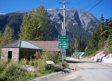
The Army Corps of Engineer’s historic Storehouse No. 4 sits astride the International Border in Hyder. It also marks the beginning of project for the paving of Salmon River Road. Photo by David Epstein, Alaska DOT&PF
- Kake – Petersburg Road – Wholly funded in the FY13 state budget, this project will upgrade 23 miles of existing logging and build 22 miles of new road to provide surface access between the two cities. Western Federal Lands Division, a sub-agency of the FHWA, will prepare the environmental documents and provide project leadership.
- LiDAR for Southeast Alaska Corridors – This was a $5,000,000 capital budget item for aerial topographic mapping of transportation corridors in Southeast Alaska. The project began in early FY13 with the selection of corridors and some initial flying. The route from the current highway terminus in Sitka to Katlian Bay was flown in the fall of 2012 and substantial flying is planned for the summers of subsequent years.
- Bostwick Rd. to Vallenar Bay – Funded at $5,000,000, this project has been re-routed and the work will be done by DNR’s Forestry Division, Ketchikan office.
- Mill Access Road Upgrade – this $2,500,000 project will upgrade three miles of single lane road on Gravina Island between Lewis Reef road and the site previously occupied by the Seley Sawmill. Bridge evaluation and preliminary work is underway.
- Ketchikan to Shelter Cove Road – This project, funded from two voter-approved GO Bonds, will be ready for construction soon. There will be a preliminary re-surfacing of an existing road segment and a reconnaissance report has been published. ROW transactions are underway along with environmental work and permitting.
- Sitka, Road Extension to Katlian Bay – This project was funded at $14,000,000 in the 2012 GO Bond. A reconnaissance site visit occurred in the fall of 2012 and LiDAR was flown at that time as well.